Zionist Entity Settlement Expansion and Agricultural Land Conversion in the West Bank, Palestine (2011–2026): A Multi-Temporal Remote Sensing Analysis
DOI:
https://doi.org/10.63318/waujpasv4i2_60Keywords:
Remote Sensing, Geographic Information Systems, Agricultural Land Conversion, Zionist Entity Settlements, West Bank, PalestineAbstract
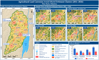
The present study was conducted to assess the changes in the Zionist Entity settlement patterns in West Bank, Palestine, between 2011 and 2026. The study focused on the changes that happened to agricultural lands. The research used the remote sensing method to analyze the data and evaluate the tendencies in the spread of settlements in the selected area. The authors used satellite images and geographic information systems (GIS) to observe the growth of the Zionist Entity settlements, recognize the new developed areas, and study the changes in the land cover. The study aimed to analyze built-up regions, agricultural land, vegetation, barren land, and water resources. It also intended to identify hotspot settlements, compare the selected clusters, observe the changes in roads, and investigate the alterations in land use within the region. The authors used a combination of image classification, change detection, overlay, and hotspot analysis methods to address the objectives of the study. The main purpose of the study was to create a basis for understanding the spread of settlements and better observe the changes related to agriculture and the nearby localities using remote sensing and GIS technology.
Downloads
Downloads
Published
Issue
Section
License
Copyright (c) 2026 The authors

This work is licensed under a Creative Commons Attribution-NonCommercial 4.0 International License.
This journal uses Creative Commons Attribution-Noncommerical 4.0 International License (CC BY-NC 4.0), which permits use, sharing, adaptation, distribution and reproduction in any medium or format, as long as you give appropriate credit to the original author(s) and the source, provide a link to the Creative Commons license, and indicate if changes were made. To view a copy of this license, visit https://creativecommons.org/licenses/by-nc/4.0/.
Copyright of articles
Authors retain copyright of their articles published in this journal.